The stages of Lake Ladoga after the Ice Age
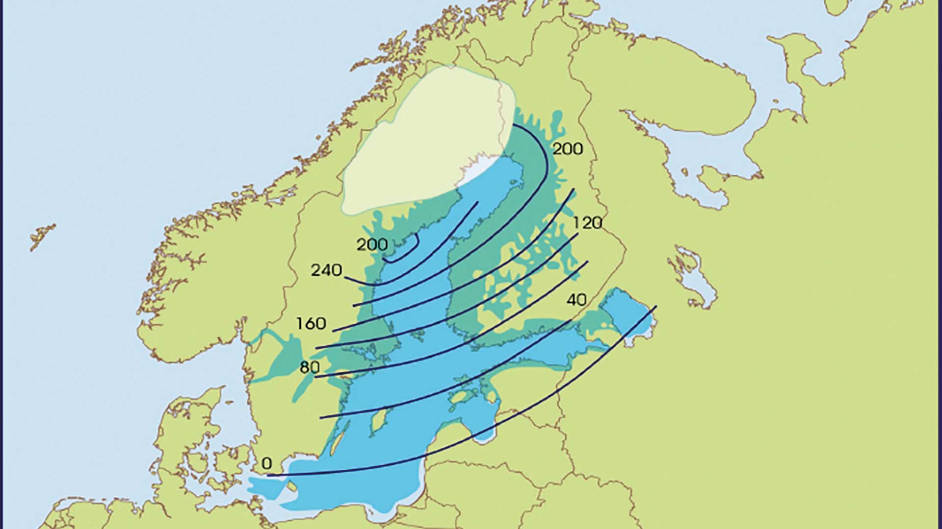
The Lake Ladoga basin has formed since the last ice age as a result of even dramatic natural upheavals. The water level of Lake Ladoga has fluctuated on numerous occasions by even tens of metres, and these fluctuations have, among other things, covered signs of settlements located on the shores of the lake beneath sediments transported by water.
The Scandinavian ice sheet began to retreat as a result of a warming climate around 17,000–18,000 years ago. The edge of the ice sheet was in the northern parts of Lake Ladoga about 13,300 years ago, and the first Salpausselkä formed at the ice margin around 12,050–12,250 years ago.
Meltwater from the glaciers formed the Baltic Ice Lake, which filled the Baltic Sea basin and Lake Ladoga, and in its final stage extended as far as the Salpausselkä ridges. The Baltic Ice Lake was tens of metres higher than the ocean surface of the time. The ocean surface, in turn, was 40 to 50 metres lower than its present level because a vast amount of water was bound in the glaciers.
At its thickest, the two-and-a-half-kilometre-thick continental ice sheet pushed the Earth's crust downwards. As the ice melted, the crust began to return to its original shape, meaning it started to rise. The uplift was and still is fastest in the Kvarken region, where the land rose by as much as ten metres per century after the continental ice sheet retreated.
Even in the Lake Ladoga region, the land initially rose by several metres per century, but the uplift was not at a uniform rate: the uplift was strongest on the north-western side of the lake and slower on the south-eastern and southern sides of the lake, meaning that the land tilted towards the south-eastern and southern shores of the lake. Nowadays, the land in the Karelia region rises by a couple of millimetres a year, or around twenty centimetres per century.
11,590 years ago, a drainage route to the ocean opened up in the Central Sweden region for the Baltic Ice Lake, and the water level of the ice lake dropped by 30 metres to the ocean level. Saline seawater entered the Baltic basin, and the ice lake turned into the brackish Yoldia Sea.
However, land uplift closed the marine connection quite rapidly, 10,500–10,700 years ago, and the Baltic basin turned back into a freshwater lake – the Ancylus Lake. Lake Ladoga and the Ancylus Lake were connected via a strait located at the Vyborg Bay and Heinjoki. The surface of the Ancylus Lake rose as land uplift raised the outlet channel in central Sweden, and the uplift was also visible at Lake Ladoga, the surface of which rose by some ten metres.
Around 10,000 years ago, a new drainage route opened to the Ancylus Lake through the Danish straits. The water level began to fall, and 9,700–9,800 years ago it dropped lower than the Vetokallio threshold located in Heinjoki. Lake Ladoga remained at a higher level than the surface of the Baltic basin, and Lake Ladoga finally became isolated as a separate lake, whose waters discharged into the Baltic basin via the Vetokallio threshold in Heinjoki.
The melting of the glaciers raised the ocean level with the result that salt water began to flow through the Danish straits into the Baltic Sea basin about 9,500 years ago. Thus the Litorina Sea was formed, which we now know as the Baltic Sea. The ocean water level stabilized at more or less its current level about 6,000 years ago.
After the isolation of Lake Ladoga, the water level in the northern parts of Lake Ladoga stabilised for several thousand years at a level determined by the Vetokallio threshold. On the low-lying southern shore of Lake Ladoga, the land rose more slowly than at the Vetokallio threshold, and consequently the water rose and the shoreline moved several kilometres inland.
Vuoksi gave birth to the River Neva
Around 5,700 years ago, Lake Ladoga's water level rose rapidly by one to two metres because the waters of Lake Saimaa broke through a new outlet at the Vuoksi, and part of the flow was diverted east into Lake Ladoga while some continued to drain west into the Gulf of Finland. This change was also the result of uneven land uplift, as the waters of Lake Saimaa initially discharged into the sea via more westerly routes.
Lake Ladoga held its ground for about 2,400 years, until around 1,350 BC, when the waters broke through the Porog threshold located in the eastern part of present-day St Petersburg and carved out a new outlet channel – the Neva. The birth of the new river must have been quite a spectacle even to contemporaries, because according to geologist Matti Saarnisto, Lake Ladoga's water level dropped by as much as 12 metres in a few years, or at most a hundred years.
The Neva remained Lake Ladoga's sole outflow, but part of the water flowing from Saimaa via the Vuoksi still emptied through Heinijoki over the Vetokallio sill into Vyborg Bay, meaning that Lake Ladoga could be accessed from the Gulf of Finland via Vyborg Bay as well as the Neva. Over the centuries, however, using this route became more difficult because the Vetokallio sill rose ever higher due to land uplift and the channel became shallower. The water level above the sill also fell as the eastern branch of the Vuoksi towards Kexholm eroded deeper and an increasing proportion of the Vuoksi's water flowed into Lake Ladoga.
The flows of the Vuoksi changed
The flows of the Vuoksi watercourse, which was important to the inhabitants of the Karelian Isthmus, changed radically in the 19th century as a result of human intervention. Lake Suvanto, located on the isthmus, had become cut off from a bay of Lake Ladoga to form a separate lake, which was separated from Lake Ladoga by a sandy flood embankment that had formed at Taipale. At the beginning of the 19th century, the surface of Lake Suvanto was a couple of metres higher than the surface of the Vuoksi and a good 12 metres higher than Lake Ladoga. A small stream flowed from Suvanto into the Vuoksi at Kiviniemi.
In 1818, at the time of the spring floods, the waters of Lake Suvanto eroded a new outlet through the Taipale isthmus, and the waters began to flow unhindered into Lake Ladoga along the Taipale River. The water level of Suvanto dropped by over six metres within a few hours and later even further, so that the level fell by a total of nearly eight metres. The lake, which had previously been higher than the surface of the Vuoksi, was now left 5.5 metres below the Vuoksi. The lakes were separated by the Kiviniemi isthmus.
Historians have debated extensively whether the Taipaleenjoki river was created with human assistance. This is hinted at by, among others, Zacharias Topelius in his book *The Book of Our Land*. The shores of Lake Suvanto were fertile, and lowering the lake had at least been planned in order to increase the area of arable land. The lowering of the water level revealed some five thousand hectares of arable land on the shores.
After the lowering of Lake Suvanto, people began to dream of a direct waterway from the Vuoksi through Suvanto to Lake Ladoga. Digging of the Kiviniemi isthmus was started, and in 1857 the gates of the channel were opened. At this stage, the surface of Lake Suvanto was already seven metres lower than that of the Vuoksi. Opening the Kiviniemi isthmus initially lowered the water level of the Vuoksi by only 3.5 metres, but by 1910 the Vuoksi's water level was already five metres lower than in 1857. The entire flow of the Vuoksi was diverted into Suvanto and further along the River Taipale to Lake Ladoga. The northern channel leading to Käkisalmi dried up almost completely, which had disastrous consequences for Käkisalmi's livelihoods. Similarly, the southern outflow channel of the Vuoksi through Heinjoki dried up.
Geologist Matti Saarnisto describes the outlet of the Vuoksi river as an unparalleled, human-induced natural disaster.
Sources:
Matti Saarnisto: The geology of Karelia: the origin of the Karelian natural landscape in the work History of the Province of Viborg I: The Origin of Karelia 2014
Matti Saarnisto: Interview 19/09/2024
Pertti Vakkilainen: The origin and development of the Taipaleenjoki river. Retrieved from http://www.sakkola.fi/tutkimukset/suvannon-lasku-1818.html


